


Autour des eoliènes

jpipacific
User
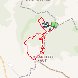

Length
7.5 km

Max alt
317 m

Uphill gradient
213 m
Km-Effort
10.4 km

Min alt
173 m

Downhill gradient
213 m
Boucle
Yes
Creation date :
2019-01-15 14:42:56.977
Updated on :
2019-01-15 14:42:56.977
1h44
Difficulty : Medium

FREE GPS app for hiking
 SityTrail
IGN / Geographical institutes
SityTrail Plus
The world is yours!
About
Trail Walking of 7.5 km to be discovered at Occitania, Tarn, Serviès. This trail is proposed by jpipacific.
Description
Randonnée se passant beaucoup en sous bois. Trop de panneaux indiquant interdit aux motos. Pourquoi ce sectarisme ?? Une moto avec un pot d'échappement d'origine et homologué n'est pas très gênante.
Positioning
Country:
France
Region :
Occitania
Department/Province :
Tarn
Municipality :
Serviès
Location:
Unknown
Start:(Dec)
Start:(UTM)
424172 ; 4835492 (31T) N.
Comments