


Virton 26km 540+

vingilles
User
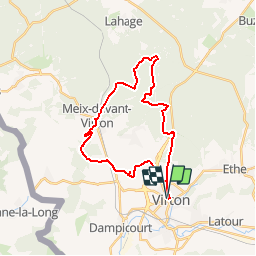

Length
25 km

Max alt
359 m

Uphill gradient
544 m
Km-Effort
33 km

Min alt
212 m

Downhill gradient
543 m
Boucle
Yes
Creation date :
2019-01-15 14:44:50.509
Updated on :
2019-01-15 14:44:50.509
2h07
Difficulty : Medium

FREE GPS app for hiking
 SityTrail
IGN / Geographical institutes
SityTrail Plus
The world is yours!
About
Trail Mountain bike of 25 km to be discovered at Wallonia, Luxembourg, Virton. This trail is proposed by vingilles.


Positioning
Country:
Belgium
Region :
Wallonia
Department/Province :
Luxembourg
Municipality :
Virton
Location:
Virton
Start:(Dec)
Start:(UTM)
682920 ; 5493759 (31U) N.
Comments