


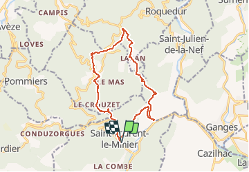
ST Laurent le Minier

ARVIEU
User

Length
15.1 km

Max alt
717 m

Uphill gradient
702 m
Km-Effort
24 km

Min alt
162 m

Downhill gradient
701 m
Boucle
Yes
Creation date :
2019-01-15 14:45:47.061
Updated on :
2019-01-15 14:45:47.061
5h01
Difficulty : Medium

FREE GPS app for hiking
 SityTrail
IGN / Geographical institutes
SityTrail Plus
The world is yours!
About
Trail Walking of 15.1 km to be discovered at Occitania, Gard, Saint-Laurent-le-Minier. This trail is proposed by ARVIEU.
Positioning
Country:
France
Region :
Occitania
Department/Province :
Gard
Municipality :
Saint-Laurent-le-Minier
Location:
Unknown
Start:(Dec)
Start:(UTM)
552757 ; 4864248 (31T) N.
Comments