


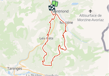
VTT(74)-Les Gets - 30 km

HG74250
User

Length
31 km

Max alt
1660 m

Uphill gradient
1224 m
Km-Effort
47 km

Min alt
936 m

Downhill gradient
1170 m
Boucle
No
Creation date :
2019-01-15 14:49:01.913
Updated on :
2020-01-04 17:34:32.979
2h58
Difficulty : Medium

FREE GPS app for hiking
 SityTrail
IGN / Geographical institutes
SityTrail Plus
The world is yours!
About
Trail Mountain bike of 31 km to be discovered at Auvergne-Rhône-Alpes, Upper Savoy, Essert-Romand. This trail is proposed by HG74250.
Positioning
Country:
France
Region :
Auvergne-Rhône-Alpes
Department/Province :
Upper Savoy
Municipality :
Essert-Romand
Location:
Unknown
Start:(Dec)
Start:(UTM)
320497 ; 5118797 (32T) N.
Comments