Trail Mountain bike Veyssilieu - Le Dauphin de l'Isle d'Abeau 2008 - 35 kms - Photo

Le Dauphin de l'Isle d'Abeau 2008 - 35 kms

 tracegps
tracegps

User

© OpenStreetMap contributors
Length
Length
34 km
Max alt
Max alt
433 m
Uphill gradient
Uphill gradient
661 m
Km-Effort
Km-Effort  
43 km
Min alt
Min alt
208 m
Downhill gradient
Downhill gradient
661 m
Boucle
Boucle
Yes
Creation date :
2014-12-10 00:00:00.0
Updated on :
2014-12-10 00:00:00.0

(2 Reviews)

Mountain bike
Mountain bike
2h30
Difficulty : Difficult

Scan this QR Code to open this trail in the SityTrail application

FREE GPS app for hiking

Logo SityTrail SityTrail

IGN / Geographical institutes

Download SityTrail from the App Store Download SityTrail from Google Play

Logo SityTrail SityTrail World

The world is yours!

Download SityTrail from the App Store Download SityTrail from Google Play Download SityTrail on Huawei AppGallery

About

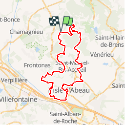
Trail Mountain bike of 34 km to be discovered at Auvergne-Rhône-Alpes, Isère, Veyssilieu. This trail is proposed by tracegps.

Description

Parcours 2008 de la randonnée VTT le Dauphin de l'Isle d'Abeau (38) Isère Nord. Circuit de 35 kms. Très beau parcours.

Elevation profile

Photos

Positioning

Country:
France
Region :
Auvergne-Rhône-Alpes
Department/Province :
Isère
Municipality :
Veyssilieu
Location:
Unknown
Start:(UTM)
672825 ; 5060944 (31T) N.

Comments

Please log in to post a review or rate the element


très bien merci


belle balade bien pensé.


Trails nearby

Trail Walking Moras - Balade autour de Crizieu - Moras - Photo
Walking
tracegps

Walking

Easy
(2)
Moras, Auvergne-Rhône-Alpes, Isère, France
5.5 km | 7.2 km-effort
1h 30min
Yes
Trail On foot Moras - etang de moras - Photo
On foot
Christophe Ontavilla

On foot

Easy
Moras, Auvergne-Rhône-Alpes, Isère, France
9 km | 11.8 km-effort
Unknown
Yes
Trail Mountain bike Crémieu - Voie verte Crémieu Arandon - Photo
Mountain bike
SyMA

Mountain bike

Very easy
Crémieu, Auvergne-Rhône-Alpes, Isère, France
41 km | 45 km-effort
3h 11min
Yes
Trail Mountain bike Chamagnieu - Rando des Etangs - Chamagnieu   - Photo
Mountain bike
tracegps

Mountain bike

Medium
Chamagnieu, Auvergne-Rhône-Alpes, Isère, France
26 km | 35 km-effort
2h 30min
Yes
Trail Mountain bike Crémieu - Le mémorial des aviateurs - Crémieu - Photo
Mountain bike
tracegps

Mountain bike

Difficult
Crémieu, Auvergne-Rhône-Alpes, Isère, France
29 km | 37 km-effort
2h 30min
Yes
Trail Walking Crémieu - Le mémorial des aviateurs - Crémieu - Photo
Walking
tracegps

Walking

Difficult
(1)
Crémieu, Auvergne-Rhône-Alpes, Isère, France
29 km | 37 km-effort
5h 30min
Yes
Trail Mountain bike Chamagnieu - Autour de Chamagnieu - Photo
Mountain bike
tracegps

Mountain bike

Difficult
Chamagnieu, Auvergne-Rhône-Alpes, Isère, France
29 km | 36 km-effort
2h 30min
Yes
Trail Walking Chamagnieu - Autour de Chamagnieu - Photo
Walking
tracegps

Walking

Difficult
Chamagnieu, Auvergne-Rhône-Alpes, Isère, France
29 km | 36 km-effort
5h 30min
Yes
Trail Walking Chozeau - muguet reconnu le 250419 - Photo
Walking
lydiaodile

Walking

Very easy
Chozeau, Auvergne-Rhône-Alpes, Isère, France
4 km | 5.7 km-effort
1h 36min
Yes


Close
My subscriptions