


dome

Maca8284
User
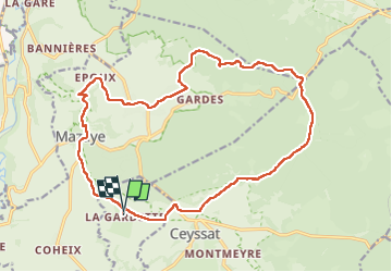

Length
19.6 km

Max alt
973 m

Uphill gradient
347 m
Km-Effort
24 km

Min alt
699 m

Downhill gradient
347 m
Boucle
Yes
Creation date :
2019-01-15 14:52:49.638
Updated on :
2019-01-15 14:52:49.638
4h40
Difficulty : Medium

FREE GPS app for hiking
 SityTrail
IGN / Geographical institutes
SityTrail Plus
The world is yours!
About
Trail Walking of 19.6 km to be discovered at Auvergne-Rhône-Alpes, Puy-de-Dôme, Olby. This trail is proposed by Maca8284.
Description
rando agréable
Photos

Positioning
Country:
France
Region :
Auvergne-Rhône-Alpes
Department/Province :
Puy-de-Dôme
Municipality :
Olby
Location:
Unknown
Start:(Dec)
Start:(UTM)
490135 ; 5068359 (31T) N.
Comments