


Foret de Mazeyes. Puit de Dome

Maca8284
User
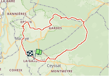

Length
21 km

Max alt
974 m

Uphill gradient
352 m
Km-Effort
25 km

Min alt
699 m

Downhill gradient
351 m
Boucle
Yes
Creation date :
2019-01-15 14:52:50.686
Updated on :
2019-01-15 14:52:50.686
4h40
Difficulty : Easy

FREE GPS app for hiking
 SityTrail
IGN / Geographical institutes
SityTrail Plus
The world is yours!
About
Trail Walking of 21 km to be discovered at Auvergne-Rhône-Alpes, Puy-de-Dôme, Olby. This trail is proposed by Maca8284.
Description
Super
Positioning
Country:
France
Region :
Auvergne-Rhône-Alpes
Department/Province :
Puy-de-Dôme
Municipality :
Olby
Location:
Unknown
Start:(Dec)
Start:(UTM)
490178 ; 5068492 (31T) N.
Comments