


j7 ERIC oingt sgmo 28k

ophness
User

Length
28 km

Max alt
520 m

Uphill gradient
536 m
Km-Effort
36 km

Min alt
187 m

Downhill gradient
807 m
Boucle
No
Creation date :
2019-01-15 14:56:46.261
Updated on :
2019-01-15 14:56:46.261
93h08
Difficulty : Unknown

FREE GPS app for hiking
 SityTrail
IGN / Geographical institutes
SityTrail Plus
The world is yours!
About
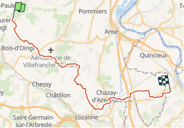
Trail Snowshoes of 28 km to be discovered at Auvergne-Rhône-Alpes, Rhône, Val d'Oingt. This trail is proposed by ophness.
Positioning
Country:
France
Region :
Auvergne-Rhône-Alpes
Department/Province :
Rhône
Municipality :
Val d'Oingt
Location:
Oingt
Start:(Dec)
Start:(UTM)
622829 ; 5089552 (31T) N.
Comments