


J1 ERIC

ophness
User
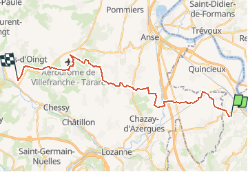

Length
26 km

Max alt
410 m

Uphill gradient
454 m
Km-Effort
31 km

Min alt
178 m

Downhill gradient
365 m
Boucle
No
Creation date :
2019-01-15 14:56:48.089
Updated on :
2019-01-15 14:56:48.089
9h27
Difficulty : Unknown

FREE GPS app for hiking
 SityTrail
IGN / Geographical institutes
SityTrail Plus
The world is yours!
About
Trail Equestrian of 26 km to be discovered at Auvergne-Rhône-Alpes, Métropole de Lyon, Saint-Germain-au-Mont-d'Or. This trail is proposed by ophness.
Positioning
Country:
France
Region :
Auvergne-Rhône-Alpes
Department/Province :
Métropole de Lyon
Municipality :
Saint-Germain-au-Mont-d'Or
Location:
Unknown
Start:(Dec)
Start:(UTM)
639484 ; 5082344 (31T) N.
Comments