


Avène-Sadde

josy31
User
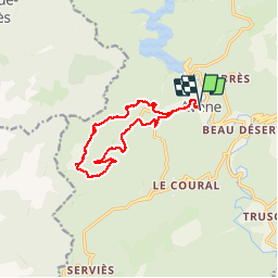

Length
12.9 km

Max alt
769 m

Uphill gradient
480 m
Km-Effort
19.3 km

Min alt
372 m

Downhill gradient
478 m
Boucle
Yes
Creation date :
2019-01-15 14:58:09.808
Updated on :
2019-01-15 14:58:09.808
4h02
Difficulty : Medium

FREE GPS app for hiking
 SityTrail
IGN / Geographical institutes
SityTrail Plus
The world is yours!
About
Trail Walking of 12.9 km to be discovered at Occitania, Hérault, Avène. This trail is proposed by josy31.
Description
Belle randonnée
Positioning
Country:
France
Region :
Occitania
Department/Province :
Hérault
Municipality :
Avène
Location:
Unknown
Start:(Dec)
Start:(UTM)
507934 ; 4844835 (31T) N.
Comments