


J3 CHLOE R

ophness
User
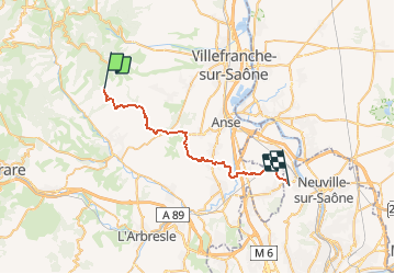

Length
30 km

Max alt
587 m

Uphill gradient
495 m
Km-Effort
37 km

Min alt
178 m

Downhill gradient
796 m
Boucle
No
Creation date :
2019-01-15 15:00:31.76
Updated on :
2019-01-15 15:00:31.76
43h16
Difficulty : Unknown

FREE GPS app for hiking
 SityTrail
IGN / Geographical institutes
SityTrail Plus
The world is yours!
About
Trail Walking of 30 km to be discovered at Auvergne-Rhône-Alpes, Rhône, Sainte-Paule. This trail is proposed by ophness.
Positioning
Country:
France
Region :
Auvergne-Rhône-Alpes
Department/Province :
Rhône
Municipality :
Sainte-Paule
Location:
Unknown
Start:(Dec)
Start:(UTM)
621220 ; 5091345 (31T) N.
Comments