Trail Mountain bike CHAMPSECRET - Espace VTT FFC les Ecureuils du Domfrontais - Circuit n°14 - Champsecret - Photo

Espace VTT FFC les Ecureuils du Domfrontais - Circuit n°14 - Champsecret

 tracegps
tracegps

User

© OpenStreetMap contributors
Length
Length
22 km
Max alt
Max alt
315 m
Uphill gradient
Uphill gradient
359 m
Km-Effort
Km-Effort  
26 km
Min alt
Min alt
196 m
Downhill gradient
Downhill gradient
358 m
Boucle
Boucle
Yes
Creation date :
2014-12-10 00:00:00.0
Updated on :
2014-12-10 00:00:00.0

(0 Reviews)

Mountain bike
Mountain bike
2h00
Difficulty : Medium

Scan this QR Code to open this trail in the SityTrail application

FREE GPS app for hiking

Logo SityTrail SityTrail

IGN / Geographical institutes

Download SityTrail from the App Store Download SityTrail from Google Play

Logo SityTrail SityTrail World

The world is yours!

Download SityTrail from the App Store Download SityTrail from Google Play Download SityTrail on Huawei AppGallery

About

Trail Mountain bike of 22 km to be discovered at Normandy, Orne. This trail is proposed by tracegps.

Description

Espace VTT - FFC Les Ecureuils du Domfrontais Circuit officiel labellisé par la Fédération Française de Cyclisme.

Elevation profile

Photos

Positioning

Country:
France
Region :
Normandy
Department/Province :
Orne
Municipality :
CHAMPSECRET
Location:
Unknown
Start:(UTM)
680543 ; 5386903 (30U) N.

Trails nearby

Trail Walking La Ferrière-aux-Étangs - 1h16 - Photo
Walking
Jeromefrando

Walking

Medium
La Ferrière-aux-Étangs, Normandy, Orne, France
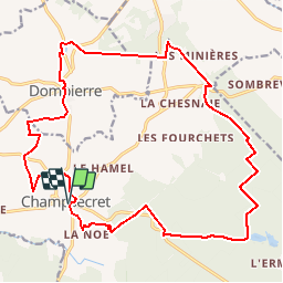
6.4 km | 8.5 km-effort
1h 16min
Yes
Trail Walking Dompierre - mines - Photo
Walking
canal

Walking

Medium
Dompierre, Normandy, Orne, France
9.3 km | 11.6 km-effort
2h 47min
No
Trail Walking Juvigny-Val-d'Andaine - Église st Geneviève  - Photo
Walking
Elisabeth Neveu

Walking

Very easy
Juvigny-Val-d'Andaine, Normandy, Orne, France
5.5 km | 6.9 km-effort
1h 43min
Yes
Trail Walking La Ferrière-aux-Étangs - La Feriere aux etant  - Photo
Walking
Elisabeth Neveu

Walking

Very easy
La Ferrière-aux-Étangs, Normandy, Orne, France
1.2 km | 1.3 km-effort
36min
Yes
Trail Walking Dompierre - Dompierre; trace GPS du 10/09/2019 - Photo
Walking
toporient

Walking

Very easy
Dompierre, Normandy, Orne, France
8.2 km | 10.2 km-effort
4h 30min
Yes
Trail Walking Dompierre - Dompierre longue - Photo
Walking
toporient

Walking

Medium
Dompierre, Normandy, Orne, France
8.3 km | 10 km-effort
2h 13min
Yes
Trail Walking Champsecret - Ermitage-Roches aux Dames et aux loups - Photo
Walking
toporient

Walking

Medium
Champsecret, Normandy, Orne, France
9 km | 11 km-effort
2h 23min
Yes
Trail Walking Saint-Bômer-les-Forges - Gare de St Bômer - Forges de Varennes - La Nocherie par la Voie Verte. - Photo
Walking
toporient

Walking

Very easy
Saint-Bômer-les-Forges, Normandy, Orne, France
8.1 km | 9.6 km-effort
2h 0min
Yes
Trail Walking  - Le Circuit du Fer (Boucle) - Photo
Walking
neitag61

Walking

Medium
, Normandy, Orne, France
20 km | 25 km-effort
5h 0min
Yes


Close
My subscriptions