


Montargis - Montcresson - St Germain des Prés

tracegps
User
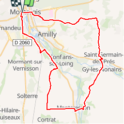

Length
38 km

Max alt
146 m

Uphill gradient
295 m
Km-Effort
42 km

Min alt
86 m

Downhill gradient
298 m
Boucle
Yes
Creation date :
2014-12-10 00:00:00.0
Updated on :
2014-12-10 00:00:00.0
2h00
Difficulty : Medium

FREE GPS app for hiking
 SityTrail
IGN / Geographical institutes
SityTrail Plus
The world is yours!
About
Trail Cycle of 38 km to be discovered at Centre-Loire Valley, Loiret, Montargis. This trail is proposed by tracegps.
Description
Montargis - Montcresson - St Germain des Prés
Positioning
Country:
France
Region :
Centre-Loire Valley
Department/Province :
Loiret
Municipality :
Montargis
Location:
Unknown
Start:(Dec)
Start:(UTM)
480077 ; 5316134 (31T) N.
Comments