


Forêt Noire tracé 4 aout 2018

Schaff
User
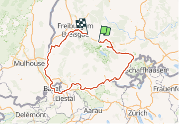

Length
248 km

Max alt
928 m

Uphill gradient
2177 m
Km-Effort
278 km

Min alt
210 m

Downhill gradient
2614 m
Boucle
No
Creation date :
2019-01-15 15:10:30.574
Updated on :
2025-05-25 16:00:34.549
0m
Difficulty : Medium

FREE GPS app for hiking
 SityTrail
IGN / Geographical institutes
SityTrail Plus
The world is yours!
About
Trail Bicycle tourism of 248 km to be discovered at Baden-Württemberg, Landkreis Breisgau-Hochschwarzwald, Hinterzarten. This trail is proposed by Schaff.
Description
Forêt Noire en vélo tracé 4
Positioning
Country:
Germany
Region :
Baden-Württemberg
Department/Province :
Landkreis Breisgau-Hochschwarzwald
Municipality :
Hinterzarten
Location:
Unknown
Start:(Dec)
Start:(UTM)
433191 ; 5306236 (32T) N.
Comments