


st cloud rouen 2

olivieraron
User
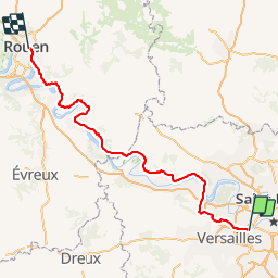

Length
169 km

Max alt
196 m

Uphill gradient
3434 m
Km-Effort
215 km

Min alt
4 m

Downhill gradient
3443 m
Boucle
No
Creation date :
2019-01-14 09:42:11.776
Updated on :
2019-01-14 09:42:12.008
11h40
Difficulty : Unknown

FREE GPS app for hiking
 SityTrail
IGN / Geographical institutes
SityTrail Plus
The world is yours!
About
Trail Mountain bike of 169 km to be discovered at Ile-de-France, Hauts-de-Seine, Sèvres. This trail is proposed by olivieraron.
Positioning
Country:
France
Region :
Ile-de-France
Department/Province :
Hauts-de-Seine
Municipality :
Sèvres
Location:
Unknown
Start:(Dec)
Start:(UTM)
443081 ; 5408635 (31U) N.
Comments