


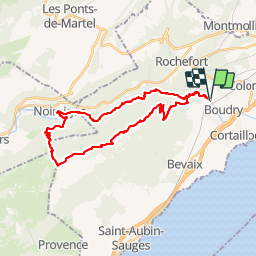
L'Areuse Creux du Vent

LaurentGILG
User

Length
32 km

Max alt
1457 m

Uphill gradient
1296 m
Km-Effort
49 km

Min alt
463 m

Downhill gradient
1296 m
Boucle
Yes
Creation date :
2019-01-20 20:50:19.872
Updated on :
2019-01-20 20:50:20.165
7h30
Difficulty : Very difficult

FREE GPS app for hiking
 SityTrail
IGN / Geographical institutes
SityTrail Plus
The world is yours!
About
Trail Walking of 32 km to be discovered at Neuchâtel, Unknown, Boudry. This trail is proposed by LaurentGILG.
Description
Départ Boudry
Positioning
Country:
Switzerland
Region :
Neuchâtel
Department/Province :
Unknown
Municipality :
Boudry
Location:
Unknown
Start:(Dec)
Start:(UTM)
334826 ; 5202909 (32T) N.
Comments
Il s'agit du Creux du Van et non du Creux du Vent!