


Granges du Moudang

gmarboeuf
User
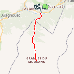

Length
11.3 km

Max alt
1538 m

Uphill gradient
519 m
Km-Effort
18.2 km

Min alt
1065 m

Downhill gradient
520 m
Boucle
Yes
Creation date :
2019-01-15 15:22:15.089
Updated on :
2019-01-15 15:22:15.089
3h44
Difficulty : Medium

FREE GPS app for hiking
 SityTrail
IGN / Geographical institutes
SityTrail Plus
The world is yours!
About
Trail Walking of 11.3 km to be discovered at Occitania, Hautespyrenees, Aragnouet. This trail is proposed by gmarboeuf.
Description
Chemin facile (accessible aux voitures). La montée principale est dans la première partie, ensuite la pente est douce. Randonnée à la portée de jeunes enfants.
Positioning
Country:
France
Region :
Occitania
Department/Province :
Hautespyrenees
Municipality :
Aragnouet
Location:
Unknown
Start:(Dec)
Start:(UTM)
274726 ; 4740755 (31T) N.
Comments