


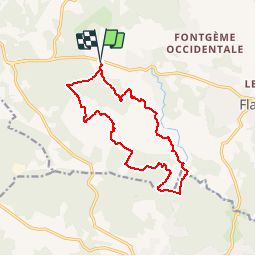
Les Oussiayes - Berne

Sugg
User

Length
14.6 km

Max alt
373 m

Uphill gradient
315 m
Km-Effort
18.8 km

Min alt
213 m

Downhill gradient
314 m
Boucle
Yes
Creation date :
2019-03-22 16:57:47.658
Updated on :
2019-03-22 16:57:47.708
4h02
Difficulty : Easy

FREE GPS app for hiking
 SityTrail
IGN / Geographical institutes
SityTrail Plus
The world is yours!
About
Trail Walking of 14.6 km to be discovered at Provence-Alpes-Côte d'Azur, Var, Flayosc. This trail is proposed by Sugg.
Description
Parcours à reconnaitre 4ème trimestre 2018.
Départ citerne Lapié sur la D557.
Positioning
Country:
France
Region :
Provence-Alpes-Côte d'Azur
Department/Province :
Var
Municipality :
Flayosc
Location:
Unknown
Start:(Dec)
Start:(UTM)
285315 ; 4824715 (32T) N.
Comments