Trail Walking Gündlischwand - Schynige Platte    First - Photo
© OpenStreetMap contributors
Length
Length
16.4 km
Max alt
Max alt
2613 m
Uphill gradient
Uphill gradient
830 m
Km-Effort
Km-Effort  
27 km
Min alt
Min alt
1913 m
Downhill gradient
Downhill gradient
647 m
Boucle
Boucle
No
Creation date :
2019-05-18 21:10:51.252
Updated on :
2019-05-18 21:10:51.373

(0 Reviews)

Walking
Walking
6h59
Difficulty : Difficult

Scan this QR Code to open this trail in the SityTrail application

FREE GPS app for hiking

Logo SityTrail SityTrail

IGN / Geographical institutes

Download SityTrail from the App Store Download SityTrail from Google Play

Logo SityTrail SityTrail World

The world is yours!

Download SityTrail from the App Store Download SityTrail from Google Play Download SityTrail on Huawei AppGallery

About

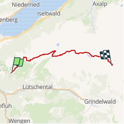
Trail Walking of 16.4 km to be discovered at Bern, Interlaken-Oberhasli administrative district, Gündlischwand. This trail is proposed by domi68440.

Description

Départ de la gare de Wildersyl en crémaillère jusqu'à la gare se Schynige 50mn. Randonnée vers First à travers les paturages avec des vues sur le lac de Thunn et de Brienz. Fe l'autre côté les sommets de l' Eiger Monsch et Jungfrau en panorama. Randonnée assez dur sur les pierres et rochers puis descente vers First. Le retour à la voiture par les télécabines vers Grindelwald puis en train jusqu'à la gare de départ.

Elevation profile

Positioning

Country:
Switzerland
Region :
Bern
Department/Province :
Interlaken-Oberhasli administrative district
Municipality :
Gündlischwand
Location:
Unknown
Start:(UTM)
416694 ; 5167113 (32T) N.

Trails nearby

Trail On foot Lauterbrunnen - CH-Isenfluh - Alpweg - Photo
On foot
PRO

On foot

Easy
Lauterbrunnen, Bern, Interlaken-Oberhasli administrative district, Switzerland
4.5 km | 7.5 km-effort
1h 42min
No
Trail On foot Lauterbrunnen - Sousegg - Sattel - Photo
On foot
PRO

On foot

Easy
Lauterbrunnen, Bern, Interlaken-Oberhasli administrative district, Switzerland
4.2 km | 10.9 km-effort
2h 29min
No
Trail Walking Gündlischwand - Schynige Platte chemin panoramique 06.07.15 - Photo
Walking
duamerg

Walking

Medium
Gündlischwand, Bern, Interlaken-Oberhasli administrative district, Switzerland
7.4 km | 11.7 km-effort
3h 0min
Yes
Trail Other activity Grindelwald - y10_kleine_scheidegg - Photo
Other activity
GUIDE+

Other activity

Very easy
Grindelwald, Bern, Interlaken-Oberhasli administrative district, Switzerland
11.5 km | 15.6 km-effort
3h 21min
No
Trail Cycle Interlaken - st_ral_3 - Photo
Cycle
GUIDE+

Cycle

Very easy
Interlaken, Bern, Interlaken-Oberhasli administrative district, Switzerland
59 km | 69 km-effort
Unknown
No
Trail Walking Gündlischwand - Eiger, Mönch und Jungfrau im Blickfeld - Photo
Walking
GUIDE+

Walking

Very easy
Gündlischwand, Bern, Interlaken-Oberhasli administrative district, Switzerland
15.9 km | 27 km-effort
Unknown
No
Trail Cycle Interlaken - st_ral_09_05 - Photo
Cycle
GUIDE+

Cycle

Very easy
Interlaken, Bern, Interlaken-Oberhasli administrative district, Switzerland
23 km | 52 km-effort
7h 28min
No
Trail Walking Interlaken - st_mt_4 - Photo
Walking
GUIDE+

Walking

Very easy
Interlaken, Bern, Interlaken-Oberhasli administrative district, Switzerland
128 km | 182 km-effort
Unknown
No
Trail Running Interlaken - Marathon_Jungfrau - Photo
Running
lhommep

Running

Very easy
Interlaken, Bern, Interlaken-Oberhasli administrative district, Switzerland
42 km | 64 km-effort
5h 30min
No


Close
My subscriptions