
SM_MONTLOGNON_8.7Km

GR77LP
User
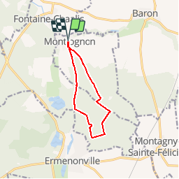

Length
8.7 km

Max alt
133 m

Uphill gradient
120 m
Km-Effort
10.3 km

Min alt
68 m

Downhill gradient
121 m
Boucle
Yes
Creation date :
2019-03-04 12:57:43.42
Updated on :
2019-03-10 19:02:10.76
2h14
Difficulty : Easy

FREE GPS app for hiking
 SityTrail
IGN / Geographical institutes
SityTrail Plus
The world is yours!
About
Trail Walking of 8.7 km to be discovered at Hauts-de-France, Oise, Montlognon. This trail is proposed by GR77LP.
Description
https://www.goelerando.fr/
DAMMARTIN en GOËLE 77
Photos

Positioning
Country:
France
Region :
Hauts-de-France
Department/Province :
Oise
Municipality :
Montlognon
Location:
Unknown
Start:(Dec)
Start:(UTM)
477669 ; 5445780 (31U) N.
Comments