


30.08.2018 - GUIPEL

babeth35
User
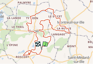

Length
26 km

Max alt
113 m

Uphill gradient
216 m
Km-Effort
29 km

Min alt
52 m

Downhill gradient
215 m
Boucle
Yes
Creation date :
2019-01-15 15:30:03.066
Updated on :
2020-07-20 15:03:06.107
6h43
Difficulty : Easy

FREE GPS app for hiking
 SityTrail
IGN / Geographical institutes
SityTrail Plus
The world is yours!
About
Trail Walking of 26 km to be discovered at Brittany, Ille-et-Vilaine, Guipel. This trail is proposed by babeth35.
Photos


Positioning
Country:
France
Region :
Brittany
Department/Province :
Ille-et-Vilaine
Municipality :
Guipel
Location:
Unknown
Start:(Dec)
Start:(UTM)
595704 ; 5348422 (30U) N.
Comments