


Montferrat Piol

Sugg
User
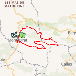

Length
14.7 km

Max alt
822 m

Uphill gradient
576 m
Km-Effort
22 km

Min alt
464 m

Downhill gradient
571 m
Boucle
Yes
Creation date :
2019-03-22 16:57:46.418
Updated on :
2019-03-22 16:57:46.468
5h00
Difficulty : Medium

FREE GPS app for hiking
 SityTrail
IGN / Geographical institutes
SityTrail Plus
The world is yours!
About
Trail Walking of 14.7 km to be discovered at Provence-Alpes-Côte d'Azur, Var, Montferrat. This trail is proposed by Sugg.
Description
Rando à reconnaître pour 4ème trimestre 2018.
Positioning
Country:
France
Region :
Provence-Alpes-Côte d'Azur
Department/Province :
Var
Municipality :
Montferrat
Location:
Unknown
Start:(Dec)
Start:(UTM)
296871 ; 4831761 (32T) N.
Comments