


84 oppede le vieux 42954

Nathy8913
User

Length
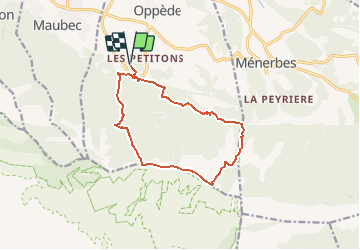
12.9 km

Max alt
725 m

Uphill gradient
716 m
Km-Effort
22 km

Min alt
187 m

Downhill gradient
719 m
Boucle
Yes
Creation date :
2019-01-15 15:36:25.209
Updated on :
2019-01-15 15:36:25.209
--
Difficulty : Difficult

FREE GPS app for hiking
 SityTrail
IGN / Geographical institutes
SityTrail Plus
The world is yours!
About
Trail Walking of 12.9 km to be discovered at Provence-Alpes-Côte d'Azur, Vaucluse, Oppède. This trail is proposed by Nathy8913.


Positioning
Country:
France
Region :
Provence-Alpes-Côte d'Azur
Department/Province :
Vaucluse
Municipality :
Oppède
Location:
Unknown
Start:(Dec)
Start:(UTM)
673670 ; 4855426 (31T) N.
Comments