


Les 3 Croix

GrouGary
User

Length
10.4 km

Max alt
334 m

Uphill gradient
455 m
Km-Effort
16.5 km

Min alt
11 m

Downhill gradient
459 m
Boucle
Yes
Creation date :
2019-01-15 15:36:59.045
Updated on :
2019-01-15 15:36:59.045
3h23
Difficulty : Medium

FREE GPS app for hiking
 SityTrail
IGN / Geographical institutes
SityTrail Plus
The world is yours!
About
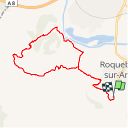
Trail Walking of 10.4 km to be discovered at Provence-Alpes-Côte d'Azur, Var, Roquebrune-sur-Argens. This trail is proposed by GrouGary.
Description
Circuit par GR 51 et quelques rochers. Retour avec mains courantes, plus impressionnant que difficile
Positioning
Country:
France
Region :
Provence-Alpes-Côte d'Azur
Department/Province :
Var
Municipality :
Roquebrune-sur-Argens
Location:
Unknown
Start:(Dec)
Start:(UTM)
308357 ; 4812029 (32T) N.
Comments