Trail Walking Valdeblore - Mont Giraud par lacs Millefonts - Photo

Mont Giraud par lacs Millefonts

 GrouGary
GrouGary

User

© OpenStreetMap contributors
Length
Length
13.9 km
Max alt
Max alt
2626 m
Uphill gradient
Uphill gradient
1014 m
Km-Effort
Km-Effort  
27 km
Min alt
Min alt
1961 m
Downhill gradient
Downhill gradient
1006 m
Boucle
Boucle
Yes
Creation date :
2019-01-15 15:37:05.899
Updated on :
2019-01-15 15:37:05.899

(0 Reviews)

Walking
Walking
5h27
Difficulty : Medium

Scan this QR Code to open this trail in the SityTrail application

FREE GPS app for hiking

Logo SityTrail SityTrail

IGN / Geographical institutes

Download SityTrail from the App Store Download SityTrail from Google Play

Logo SityTrail SityTrail Plus

The world is yours!

Download SityTrail from the App Store Download SityTrail from Google Play Download SityTrail on Huawei AppGallery

About

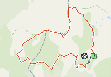
Trail Walking of 13.9 km to be discovered at Provence-Alpes-Côte d'Azur, Maritime Alps, Valdeblore. This trail is proposed by GrouGary.

Description

Boucle longue sur les cretes. Pas de balisage mais orientation facile sans brouillard. Descente raide dans pelouse et surtout pierriers. Évitez descente sur Vacherie car le berger est un furieux qui défend son "territoire", ... même si le balisage jaune le rend légitimement accessible aux randonneurs.

Elevation profile

Positioning

Country:
France
Region :
Provence-Alpes-Côte d'Azur
Department/Province :
Maritime Alps
Municipality :
Valdeblore
Location:
Unknown
Start:(UTM)
354883 ; 4884426 (32T) N.


Close
My subscriptions