


arbas fait

pidjam
User
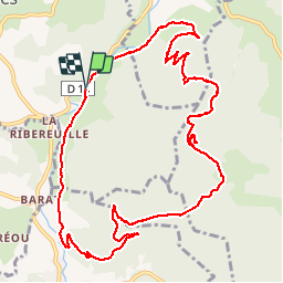

Length
13.5 km

Max alt
730 m

Uphill gradient
461 m
Km-Effort
19.6 km

Min alt
369 m

Downhill gradient
458 m
Boucle
Yes
Creation date :
2019-01-15 15:38:34.749
Updated on :
2019-01-15 15:38:34.749
3h06
Difficulty : Unknown

FREE GPS app for hiking
 SityTrail
IGN / Geographical institutes
SityTrail Plus
The world is yours!
About
Trail Walking of 13.5 km to be discovered at Occitania, Haute-Garonne, Montastruc-de-Salies. This trail is proposed by pidjam.
Positioning
Country:
France
Region :
Occitania
Department/Province :
Haute-Garonne
Municipality :
Montastruc-de-Salies
Location:
Unknown
Start:(Dec)
Start:(UTM)
329726 ; 4765070 (31T) N.
Comments