


Untitled

HG74250
User
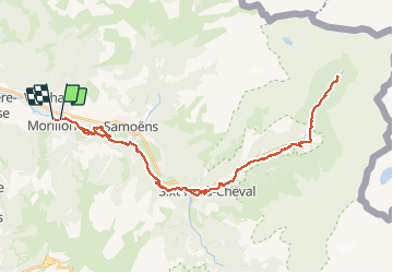

Length
42 km

Max alt
1072 m

Uphill gradient
809 m
Km-Effort
53 km

Min alt
664 m

Downhill gradient
816 m
Boucle
No
Creation date :
2019-01-15 15:38:44.693
Updated on :
2020-01-04 17:32:20.895
3h32
Difficulty : Easy

FREE GPS app for hiking
 SityTrail
IGN / Geographical institutes
SityTrail Plus
The world is yours!
About
Trail Mountain bike of 42 km to be discovered at Auvergne-Rhône-Alpes, Upper Savoy, Morillon. This trail is proposed by HG74250.
Positioning
Country:
France
Region :
Auvergne-Rhône-Alpes
Department/Province :
Upper Savoy
Municipality :
Morillon
Location:
Unknown
Start:(Dec)
Start:(UTM)
320889 ; 5106227 (32T) N.
Comments