


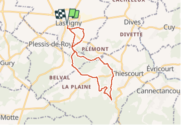
Circuit pédestre Lassigny

tracegps
User

Length
12.3 km

Max alt
165 m

Uphill gradient
278 m
Km-Effort
16 km

Min alt
60 m

Downhill gradient
278 m
Boucle
Yes
Creation date :
2014-12-10 00:00:00.0
Updated on :
2014-12-10 00:00:00.0
3h00
Difficulty : Difficult

FREE GPS app for hiking
 SityTrail
IGN / Geographical institutes
SityTrail Plus
The world is yours!
About
Trail Walking of 12.3 km to be discovered at Hauts-de-France, Oise, Lassigny. This trail is proposed by tracegps.
Description
Découvrez la montagne du Plémont et la Chapelle Saint Albin en partant de la Place de Lassigny.
Positioning
Country:
France
Region :
Hauts-de-France
Department/Province :
Oise
Municipality :
Lassigny
Location:
Unknown
Start:(Dec)
Start:(UTM)
488601 ; 5492738 (31U) N.
Comments