


L'abbaye

raymondfn
User
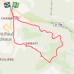

Length
8.5 km

Max alt
764 m

Uphill gradient
333 m
Km-Effort
13 km

Min alt
480 m

Downhill gradient
334 m
Boucle
Yes
Creation date :
2019-01-03 22:01:05.235
Updated on :
2019-01-03 22:01:05.235
2h42
Difficulty : Medium

FREE GPS app for hiking
 SityTrail
IGN / Geographical institutes
SityTrail Plus
The world is yours!
About
Trail Walking of 8.5 km to be discovered at Auvergne-Rhône-Alpes, Isère, Izeaux. This trail is proposed by raymondfn.
Positioning
Country:
France
Region :
Auvergne-Rhône-Alpes
Department/Province :
Isère
Municipality :
Izeaux
Location:
Unknown
Start:(Dec)
Start:(UTM)
690726 ; 5022164 (31T) N.
Comments