Trail Mountain bike Fosseux - Lucheux - Photo
 tracegps
tracegps

User

© OpenStreetMap contributors
Length
Length
44 km
Max alt
Max alt
174 m
Uphill gradient
Uphill gradient
448 m
Km-Effort
Km-Effort  
50 km
Min alt
Min alt
78 m
Downhill gradient
Downhill gradient
450 m
Boucle
Boucle
Yes
Creation date :
2014-12-10 00:00:00.0
Updated on :
2014-12-10 00:00:00.0

(2 Reviews)

Mountain bike
Mountain bike
3h00
Difficulty : Medium

Scan this QR Code to open this trail in the SityTrail application

FREE GPS app for hiking

Logo SityTrail SityTrail

IGN / Geographical institutes

Download SityTrail from the App Store Download SityTrail from Google Play

Logo SityTrail SityTrail World

The world is yours!

Download SityTrail from the App Store Download SityTrail from Google Play Download SityTrail on Huawei AppGallery

About

Trail Mountain bike of 44 km to be discovered at Hauts-de-France, Pas-de-Calais, Fosseux. This trail is proposed by tracegps.

Description

Départ du circuit près de Avesnes le Comte, Circuit très roulant jusqu'à Lucheux où à partir de là tout ce complique! Circuit de 44 km avec bitume et sous bois à faire absolument

Elevation profile

Positioning

Country:
France
Region :
Hauts-de-France
Department/Province :
Pas-de-Calais
Municipality :
Fosseux
Location:
Unknown
Start:(UTM)
468780 ; 5567265 (31U) N.

Comments

Please log in to post a review or rate the element


super a faire


Trails nearby

Trail Mountain bike Avesnes-le-Comte - Les 6 châteaux - Avesnes le Comte - Photo
Mountain bike
tracegps

Mountain bike

Difficult
(1)
Avesnes-le-Comte, Hauts-de-France, Pas-de-Calais, France
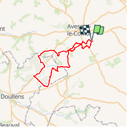
44 km | 50 km-effort
2h 10min
Yes
Trail Walking Avesnes-le-Comte - Avesnes le Comte, Noyelle-Vion, Manin, Beaufort-Blavincourt - Photo
Walking
tracegps

Walking

Medium
Avesnes-le-Comte, Hauts-de-France, Pas-de-Calais, France
10.8 km | 12.2 km-effort
2h 30min
Yes
Trail Walking Hauteville - Randonnée autour de Hauteville - Barly - Fosseux - Photo
Walking
tracegps

Walking

Medium
Hauteville, Hauts-de-France, Pas-de-Calais, France
10.4 km | 11.8 km-effort
2h 0min
Yes
Trail Walking Montenescourt - Montenescourt - Gouves - Wanquetin - Photo
Walking
tracegps

Walking

Medium
Montenescourt, Hauts-de-France, Pas-de-Calais, France
10.6 km | 11.9 km-effort
2h 0min
Yes
Trail Walking Bavincourt - Le sentier de la longue Borne - Bavincourt - Photo
Walking
tracegps

Walking

Medium
Bavincourt, Hauts-de-France, Pas-de-Calais, France
9.8 km | 10.9 km-effort
2h 30min
Yes
Trail Walking Gouy-en-Artois - Le sentier des loups - Gouy en Artois - Photo
Walking
tracegps

Walking

Difficult
Gouy-en-Artois, Hauts-de-France, Pas-de-Calais, France
14.2 km | 15.9 km-effort
3h 34min
Yes
Trail Walking Montenescourt - Montenescourt Habarcq Hermaville Bois d'Habarcq - Photo
Walking
tracegps

Walking

Medium
Montenescourt, Hauts-de-France, Pas-de-Calais, France
11 km | 12.9 km-effort
2h 0min
Yes
Trail Walking Givenchy-le-Noble - Givenchy le Noble - Ambrines - Denier - Lignereuil - Photo
Walking
tracegps

Walking

Medium
Givenchy-le-Noble, Hauts-de-France, Pas-de-Calais, France
11 km | 12.5 km-effort
2h 0min
Yes
Trail Walking Montenescourt - Montenescourt - Wanquetin - Noyellette - Habarcq - Gouves - Photo
Walking
tracegps

Walking

Medium
Montenescourt, Hauts-de-France, Pas-de-Calais, France
10.1 km | 11.2 km-effort
2h 0min
Yes


Close
My subscriptions