


col de fer

barney06
User
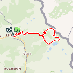

Length
17.8 km

Max alt
2628 m

Uphill gradient
1126 m
Km-Effort
33 km

Min alt
1651 m

Downhill gradient
1124 m
Boucle
Yes
Creation date :
2019-01-15 15:47:03.621
Updated on :
2019-01-15 15:47:03.621
8h26
Difficulty : Medium

FREE GPS app for hiking
 SityTrail
IGN / Geographical institutes
SityTrail Plus
The world is yours!
About
Trail Walking of 17.8 km to be discovered at Provence-Alpes-Côte d'Azur, Maritime Alps, Saint-Étienne-de-Tinée. This trail is proposed by barney06.
Description
randonnées
Positioning
Country:
France
Region :
Provence-Alpes-Côte d'Azur
Department/Province :
Maritime Alps
Municipality :
Saint-Étienne-de-Tinée
Location:
Unknown
Start:(Dec)
Start:(UTM)
331512 ; 4909785 (32T) N.
Comments