


Theux

Lychee
User

Length
28 km

Max alt
389 m

Uphill gradient
648 m
Km-Effort
37 km

Min alt
167 m

Downhill gradient
564 m
Boucle
No
Creation date :
2019-03-14 09:53:02.903
Updated on :
2019-03-14 15:13:51.658
7h27
Difficulty : Difficult

FREE GPS app for hiking
 SityTrail
IGN / Geographical institutes
SityTrail Plus
The world is yours!
About
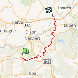
Trail Walking of 28 km to be discovered at Wallonia, Liège, Theux. This trail is proposed by Lychee.
Description
au départ de Theux retour sur Welky
Photos


Positioning
Country:
Belgium
Region :
Wallonia
Department/Province :
Liège
Municipality :
Theux
Location:
Theux
Start:(Dec)
Start:(UTM)
699470 ; 5602106 (31U) N.
Comments