


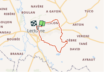
Espace VTT FFC Vallons du Lectourois - Lectoure - Circuit n°4

tracegps
User


1h19
Difficulty : Difficult

FREE GPS app for hiking
 SityTrail
IGN / Geographical institutes
SityTrail Plus
The world is yours!
About
Trail Mountain bike of 11.2 km to be discovered at Occitania, Gers, Lectoure. This trail is proposed by tracegps.
Description
Espace VTT FFC Vallons du Lectourois cœur de Gascogne - Lectoure - Circuit n°4. Circuit officiel labellisé par la Fédération Française de Cyclisme. Circuit de 12 Kms pour apprécier la Vallée du Touron typique du pays Lectourois. Circuit numérisé par la Communauté de Communes de la Lomagne Gersoise.
Photos


Positioning
Comments