


Montferrand/Torcieu 18,8 km - D. 709 m

Thomasdanielle
User
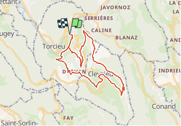

Length
18.8 km

Max alt
820 m

Uphill gradient
709 m
Km-Effort
28 km

Min alt
267 m

Downhill gradient
709 m
Boucle
Yes
Creation date :
2019-01-15 16:03:06.892
Updated on :
2019-01-15 16:03:06.892
5h53
Difficulty : Medium

FREE GPS app for hiking
 SityTrail
IGN / Geographical institutes
SityTrail Plus
The world is yours!
About
Trail Walking of 18.8 km to be discovered at Auvergne-Rhône-Alpes, Ain, Torcieu. This trail is proposed by Thomasdanielle.
Description
D/A Avant le passage à niveau de Montferrant
Randonnée difficile avec des mains courantes, sur chemin étroit. DANGER réserver à des sportifs
Photos


Positioning
Country:
France
Region :
Auvergne-Rhône-Alpes
Department/Province :
Ain
Municipality :
Torcieu
Location:
Unknown
Start:(Dec)
Start:(UTM)
686715 ; 5088728 (31T) N.
Comments