


taillefer

Ajax44
User
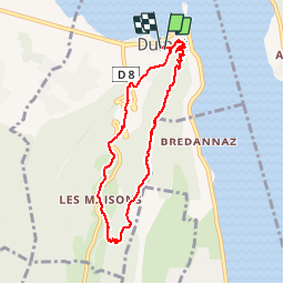

Length
7.3 km

Max alt
765 m

Uphill gradient
344 m
Km-Effort
11.9 km

Min alt
451 m

Downhill gradient
345 m
Boucle
Yes
Creation date :
2019-01-15 16:03:48.716
Updated on :
2019-01-15 16:03:48.716
2h50
Difficulty : Medium

FREE GPS app for hiking
 SityTrail
IGN / Geographical institutes
SityTrail Plus
The world is yours!
About
Trail Walking of 7.3 km to be discovered at Auvergne-Rhône-Alpes, Upper Savoy, Duingt. This trail is proposed by Ajax44.
Positioning
Country:
France
Region :
Auvergne-Rhône-Alpes
Department/Province :
Upper Savoy
Municipality :
Duingt
Location:
Unknown
Start:(Dec)
Start:(UTM)
282737 ; 5078643 (32T) N.
Comments