Trail Walking Roquefort-la-Bédoule - Barres de Font Blanche - Photo
 tracegps
tracegps

User

© OpenStreetMap contributors
Length
Length
10.3 km
Max alt
Max alt
458 m
Uphill gradient
Uphill gradient
301 m
Km-Effort
Km-Effort  
14.4 km
Min alt
Min alt
286 m
Downhill gradient
Downhill gradient
303 m
Boucle
Boucle
Yes
Creation date :
2014-12-10 00:00:00.0
Updated on :
2014-12-10 00:00:00.0

(1 Reviews)

Walking
Walking
2h19
Difficulty : Medium

Scan this QR Code to open this trail in the SityTrail application

FREE GPS app for hiking

Logo SityTrail SityTrail

IGN / Geographical institutes

Download SityTrail from the App Store Download SityTrail from Google Play

Logo SityTrail SityTrail World

The world is yours!

Download SityTrail from the App Store Download SityTrail from Google Play Download SityTrail on Huawei AppGallery

About

Trail Walking of 10.3 km to be discovered at Provence-Alpes-Côte d'Azur, Bouches-du-Rhône, Roquefort-la-Bédoule. This trail is proposed by tracegps.

Description

Belle randonnée pédestre de niveau 3. Vous pourrez vous stationner au point de départ. Vous marcherez sur des pistes DFCI ou des chemins faciles et boisés. D’autres informations sur le site de Rando Loisirs à Carnoux en Provence.

Elevation profile

Photos

Positioning

Country:
France
Region :
Provence-Alpes-Côte d'Azur
Department/Province :
Bouches-du-Rhône
Municipality :
Roquefort-la-Bédoule
Location:
Unknown
Start:(UTM)
718272 ; 4790949 (31T) N.

Comments

Please log in to post a review or rate the element


Trails nearby

Trail Walking Roquefort-la-Bédoule - Grand Caunet, le Montounier - Photo
Walking
GUIDE
affinetataille

Walking

Medium
(1)
Roquefort-la-Bédoule, Provence-Alpes-Côte d'Azur, Bouches-du-Rhône, France
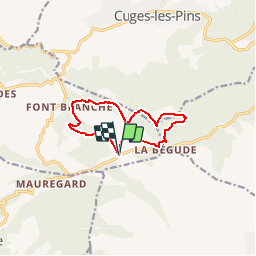
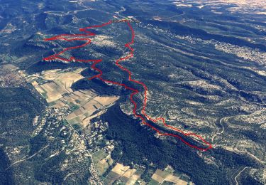
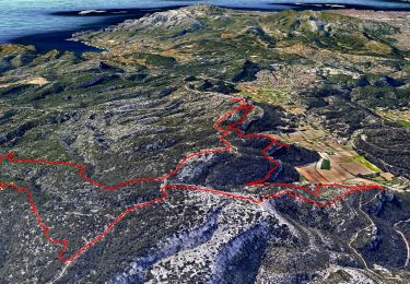
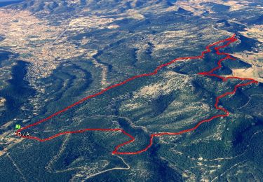
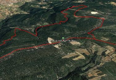
16.5 km | 24 km-effort
6h 0min
Yes
Trail Walking Ceyreste - Autour du Montounier 2eme version - Photo
Walking
GUIDE
affinetataille

Walking

Medium
(1)
Ceyreste, Provence-Alpes-Côte d'Azur, Bouches-du-Rhône, France
15.7 km | 24 km-effort
6h 0min
Yes
Trail Walking Roquefort-la-Bédoule - SityTrail - Grand Caunet, Cabanons, Vigie , Grotte Raymond, Ruines roquefort, Chapelle St andré - Photo
Walking
GUIDE
affinetataille

Walking

Easy
(1)
Roquefort-la-Bédoule, Provence-Alpes-Côte d'Azur, Bouches-du-Rhône, France
14.2 km | 19.9 km-effort
6h 0min
Yes
Trail Walking Le Castellet - SityTrail - 2361987 - begude - Photo
Walking
GUIDE
affinetataille

Walking

Medium
(1)
Le Castellet, Provence-Alpes-Côte d'Azur, Var, France
11.5 km | 15.1 km-effort
4h 0min
Yes
Trail Nordic walking La Cadière-d'Azur - 20220329_La Cadière d'Azur - Photo
Nordic walking
Marcsaintcyr

Nordic walking

Very easy
(1)
La Cadière-d'Azur, Provence-Alpes-Côte d'Azur, Var, France
6.8 km | 8.6 km-effort
1h 30min
Yes
Trail Nordic walking La Cadière-d'Azur - 20220329_La Cadière d'Azur - Photo
Nordic walking
Marcsaintcyr

Nordic walking

Very easy
(1)
La Cadière-d'Azur, Provence-Alpes-Côte d'Azur, Var, France
6.8 km | 8.6 km-effort
1h 30min
Yes
Trail Walking Cuges-les-Pins - cuges barres de castillon OK coral - Photo
Walking
michelpaulin

Walking

Medium
(1)
Cuges-les-Pins, Provence-Alpes-Côte d'Azur, Bouches-du-Rhône, France
10.9 km | 14.9 km-effort
5h 54min
Yes
Trail Walking Cuges-les-Pins - Col de l'Ange Vallon de Julie & de Gypières  - Photo
Walking
reymond83

Walking

Medium
(1)
Cuges-les-Pins, Provence-Alpes-Côte d'Azur, Bouches-du-Rhône, France
13.4 km | 21 km-effort
3h 30min
Yes
Trail Mountain bike Gémenos - 2013 03 09 bourbonne  - Photo
Mountain bike
lboubis

Mountain bike

Medium
(1)
Gémenos, Provence-Alpes-Côte d'Azur, Bouches-du-Rhône, France
18.9 km | 26 km-effort
1h 41min
Yes


Close
My subscriptions