


Rando Carnoux Cassis Carnoux

tracegps
User


2h30
Difficulty : Medium

FREE GPS app for hiking
 SityTrail
IGN / Geographical institutes
SityTrail Plus
The world is yours!
About
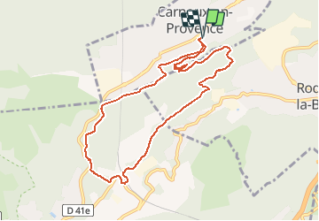
Trail Walking of 10.1 km to be discovered at Provence-Alpes-Côte d'Azur, Bouches-du-Rhône, Carnoux-en-Provence. This trail is proposed by tracegps.
Description
En partant de la place face à la mairie de Carnoux cette randonnée emprunte en premier le sentier botanique puis après un périple dans les sentiers vallonnées arrivée à la gare de Cassis puis retour vers Carnoux. Vue sur le cap Canaille. D’autres informations sur le site de Rando Loisirs à Carnoux en Provence.
Photos

Positioning
Comments