


Virades de l'Espoir BJ Parcours bleu

Ardeiserois
User
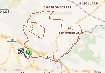

Length
13.1 km

Max alt
367 m

Uphill gradient
257 m
Km-Effort
16.5 km

Min alt
233 m

Downhill gradient
256 m
Boucle
Yes
Creation date :
2019-01-15 16:04:11.876
Updated on :
2019-08-01 09:17:18.842
3h33
Difficulty : Unknown

FREE GPS app for hiking
 SityTrail
IGN / Geographical institutes
SityTrail Plus
The world is yours!
About
Trail Walking of 13.1 km to be discovered at Auvergne-Rhône-Alpes, Isère, Bourgoin-Jallieu. This trail is proposed by Ardeiserois.
Positioning
Country:
France
Region :
Auvergne-Rhône-Alpes
Department/Province :
Isère
Municipality :
Bourgoin-Jallieu
Location:
Unknown
Start:(Dec)
Start:(UTM)
677438 ; 5051414 (31T) N.
Comments