Trail Walking Plan-d'Aups-Sainte-Baume - La Grotte aux oiseaux - Plan d'Aups  - Photo

La Grotte aux oiseaux - Plan d'Aups

 tracegps
tracegps

User

© OpenStreetMap contributors
Length
Length
8.8 km
Max alt
Max alt
721 m
Uphill gradient
Uphill gradient
276 m
Km-Effort
Km-Effort  
12.5 km
Min alt
Min alt
517 m
Downhill gradient
Downhill gradient
274 m
Boucle
Boucle
Yes
Creation date :
2014-12-10 00:00:00.0
Updated on :
2014-12-10 00:00:00.0

(1 Reviews)

Walking
Walking
2h30
Difficulty : Medium

Scan this QR Code to open this trail in the SityTrail application

FREE GPS app for hiking

Logo SityTrail SityTrail

IGN / Geographical institutes

Download SityTrail from the App Store Download SityTrail from Google Play

Logo SityTrail SityTrail World

The world is yours!

Download SityTrail from the App Store Download SityTrail from Google Play Download SityTrail on Huawei AppGallery

About

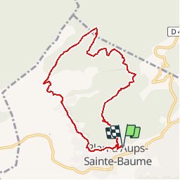
Trail Walking of 8.8 km to be discovered at Provence-Alpes-Côte d'Azur, Var, Plan-d'Aups-Sainte-Baume. This trail is proposed by tracegps.

Description

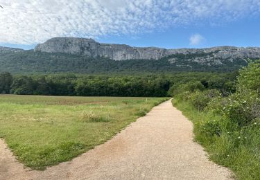
Belle randonnée de niveau 3. Parking Plan d'Aups. Belles vues sur la montagne sainte Baume et la forêt domaniale. D’autres informations sur le site de Rando Loisirs à Carnoux en Provence.

Elevation profile

Photos

Positioning

Country:
France
Region :
Provence-Alpes-Côte d'Azur
Department/Province :
Var
Municipality :
Plan-d'Aups-Sainte-Baume
Location:
Unknown
Start:(UTM)
720187 ; 4801124 (31T) N.

Comments

Please log in to post a review or rate the element


Trails nearby

Trail Walking Plan-d'Aups-Sainte-Baume - Sainte Baume 8,5 km - Photo
Walking
GUIDE
rvapeldo

Walking

Medium
(1)
Plan-d'Aups-Sainte-Baume, Provence-Alpes-Côte d'Azur, Var, France
8.4 km | 15.5 km-effort
4h 38min
Yes
Trail Walking Plan-d'Aups-Sainte-Baume - SityTrail - Sentier merveilleux - La Ste baume - Le Plan d'aups  - Photo
Walking
GUIDE
affinetataille

Walking

Medium
(1)
Plan-d'Aups-Sainte-Baume, Provence-Alpes-Côte d'Azur, Var, France
15 km | 23 km-effort
6h 0min
Yes
Trail Walking Gémenos - dent de roque forcade. cauvin.bertagne. 2 avril 2018 - Photo
Walking
marchev

Walking

Medium
(1)
Gémenos, Provence-Alpes-Côte d'Azur, Bouches-du-Rhône, France
12.7 km | 20 km-effort
4h 31min
Yes
Trail Walking Auriol - la crete des infernets - Photo
Walking
Coryphene

Walking

Difficult
(1)
Auriol, Provence-Alpes-Côte d'Azur, Bouches-du-Rhône, France
8.6 km | 14 km-effort
3h 22min
Yes
Trail Walking Plan-d'Aups-Sainte-Baume - Crêts de la Ste Baume - Photo
Walking
tracegps

Walking

Medium
(2)
Plan-d'Aups-Sainte-Baume, Provence-Alpes-Côte d'Azur, Var, France
15.4 km | 23 km-effort
5h 0min
Yes
Trail Walking Gémenos - Autour des Dents de Roque Forcade, Tour de Cauvin - Photo
Walking
tracegps

Walking

Difficult
(1)
Gémenos, Provence-Alpes-Côte d'Azur, Bouches-du-Rhône, France
7.6 km | 11.7 km-effort
3h 15min
Yes
Trail Walking Plan-d'Aups-Sainte-Baume - Du Col du Saint-Pilon au Pas de l'Aï, Sainte Baume - Photo
Walking
tracegps

Walking

Medium
(1)
Plan-d'Aups-Sainte-Baume, Provence-Alpes-Côte d'Azur, Var, France
13.1 km | 20 km-effort
5h 15min
Yes
Trail Walking Riboux - Riboux - Forêt de Malaucène - Photo
Walking
tracegps

Walking

Medium
(4)
Riboux, Provence-Alpes-Côte d'Azur, Var, France
12.2 km | 15.2 km-effort
2h 40min
Yes
Trail On foot Plan-d'Aups-Sainte-Baume - Massif Sainte Baume et pas de l’Aï 15 km - Photo
On foot
GUIDE
rvapeldo

On foot

Medium
Plan-d'Aups-Sainte-Baume, Provence-Alpes-Côte d'Azur, Var, France
15 km | 22 km-effort
5h 0min
Yes


Close
My subscriptions