Trail Walking Albigny-sur-Saône - 
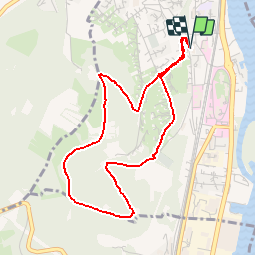
Parcours de santé - Albigny - Photo
 tracegps
tracegps

User

© OpenStreetMap contributors
Length
Length
4.3 km
Max alt
Max alt
406 m
Uphill gradient
Uphill gradient
223 m
Km-Effort
Km-Effort  
7.3 km
Min alt
Min alt
180 m
Downhill gradient
Downhill gradient
225 m
Boucle
Boucle
Yes
Creation date :
2014-12-10 00:00:00.0
Updated on :
2014-12-10 00:00:00.0

(0 Reviews)

Walking
Walking
2h30
Difficulty : Medium

Scan this QR Code to open this trail in the SityTrail application

FREE GPS app for hiking

Logo SityTrail SityTrail

IGN / Geographical institutes

Download SityTrail from the App Store Download SityTrail from Google Play

Logo SityTrail SityTrail Plus

The world is yours!

Download SityTrail from the App Store Download SityTrail from Google Play Download SityTrail on Huawei AppGallery

About

Trail Walking of 4.3 km to be discovered at Auvergne-Rhône-Alpes, Métropole de Lyon, Albigny-sur-Saône. This trail is proposed by tracegps.

Description

- Parcours avec de nombreux passages encombrés par des pierres. Sur le parcours, nous trouvons des agrès de musculation et 2 endroits de point de vue équipés de point de visée explicatif. - Il est dommage que plus rien ne soit entretenu (des agrès endommagés et manquant et les chemins encombrés par des pierres et des éboulis de murs de pierres sèches construits par nos ancêtres lointains)

Elevation profile

Positioning

Country:
France
Region :
Auvergne-Rhône-Alpes
Department/Province :
Métropole de Lyon
Municipality :
Albigny-sur-Saône
Location:
Unknown
Start:(UTM)
642171 ; 5080641 (31T) N.


Close
My subscriptions