


Redon

chasle
User
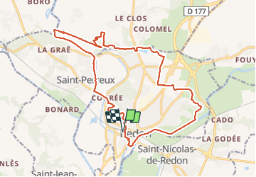

Length
21 km

Max alt
77 m

Uphill gradient
292 m
Km-Effort
25 km

Min alt
0 m

Downhill gradient
292 m
Boucle
Yes
Creation date :
2019-01-15 16:10:11.131
Updated on :
2019-01-15 16:10:11.131
5h23
Difficulty : Easy

FREE GPS app for hiking
 SityTrail
IGN / Geographical institutes
SityTrail Plus
The world is yours!
About
Trail Walking of 21 km to be discovered at Brittany, Ille-et-Vilaine, Redon. This trail is proposed by chasle.
Description
A la croisée de la Loire-Atlantique, de l'Ille et Vilaine et du Morbihan
Positioning
Country:
France
Region :
Brittany
Department/Province :
Ille-et-Vilaine
Municipality :
Redon
Location:
Unknown
Start:(Dec)
Start:(UTM)
568338 ; 5277964 (30T) N.
Comments