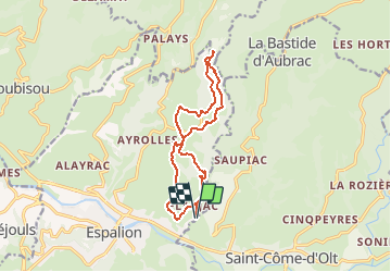
Flaujac - Abbaye de Bonneval

tracegps
User


4h00
Difficulty : Difficult

FREE GPS app for hiking
 SityTrail
IGN / Geographical institutes
SityTrail Plus
The world is yours!
About
Trail Walking of 13.3 km to be discovered at Occitania, Aveyron, Espalion. This trail is proposed by tracegps.
Description
Départ FLAUJAC (parking 200 mètres avant le village, à proximité de la Boralde Flaujaguèse). Se diriger au Nord. Accéder sur le plateau en passant à proximité de la Tour de MASSE. Continuer jusqu'à FALGUIERES, PUSSAC et arriver à l'Abbaye de BONNEVAL. Revenir, par un très beau sentier, à travers bois, en passant par LA GUIRARDIE, FERRANDES et dans la Vallée FLAUJAC.
Photos


Positioning
Comments