


Saint May Plateau de St Laurent

collot
User
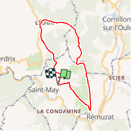

Length
14.2 km

Max alt
1041 m

Uphill gradient
674 m
Km-Effort
23 km

Min alt
594 m

Downhill gradient
682 m
Boucle
Yes
Creation date :
2019-01-15 16:18:15.448
Updated on :
2019-01-15 16:18:15.448
4h00
Difficulty : Medium

FREE GPS app for hiking
 SityTrail
IGN / Geographical institutes
SityTrail Plus
The world is yours!
About
Trail Walking of 14.2 km to be discovered at Auvergne-Rhône-Alpes, Drôme, Saint-May. This trail is proposed by collot.
Description
Sans difficulté, randonnée intéressante pour ses panoramas et observations des vautours.
Positioning
Country:
France
Region :
Auvergne-Rhône-Alpes
Department/Province :
Drôme
Municipality :
Saint-May
Location:
Unknown
Start:(Dec)
Start:(UTM)
685311 ; 4922124 (31T) N.
Comments