Trail Mountain bike Lardy - Autour de Lardy en VTT - Photo

Autour de Lardy en VTT

 tracegps
tracegps

User

© OpenStreetMap contributors
Length
Length
31 km
Max alt
Max alt
160 m
Uphill gradient
Uphill gradient
493 m
Km-Effort
Km-Effort  
38 km
Min alt
Min alt
57 m
Downhill gradient
Downhill gradient
502 m
Boucle
Boucle
Yes
Creation date :
2014-12-10 00:00:00.0
Updated on :
2014-12-10 00:00:00.0

(1 Reviews)

Mountain bike
Mountain bike
2h04
Difficulty : Medium

Scan this QR Code to open this trail in the SityTrail application

FREE GPS app for hiking

Logo SityTrail SityTrail

IGN / Geographical institutes

Download SityTrail from the App Store Download SityTrail from Google Play

Logo SityTrail SityTrail World

The world is yours!

Download SityTrail from the App Store Download SityTrail from Google Play Download SityTrail on Huawei AppGallery

About

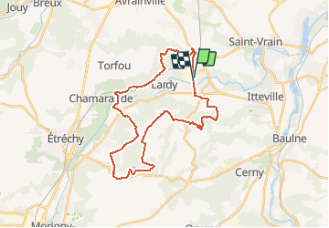
Trail Mountain bike of 31 km to be discovered at Ile-de-France, Essonne, Lardy. This trail is proposed by tracegps.

Description

Rando VTT organisée par le Club Omni-Sport de Renault Lardy le 08/11/2009. Le départ se trouve 1 allée Cornuel 91510 LARDY. Les statistiques enregistrées sont celles du Club de VTT de Fontenay sous Bois

Elevation profile

Photos

Positioning

Country:
France
Region :
Ile-de-France
Department/Province :
Essonne
Municipality :
Lardy
Location:
Unknown
Start:(UTM)
447407 ; 5374718 (31U) N.

Comments

Please log in to post a review or rate the element


Pour un petit décrassage ou en famille, un parcours très sympa. Je confirme, la montée du départ est raide attention à pas vous cramer, mieux vaut montée à pied. Après c'est un parcours varié très agréable. Rando plutôt plaisir que perf. Merci Bastet.


Trails nearby

Trail Walking Lardy - Lardy - Chamarande -F - Photo
Walking
nicolas93

Walking

Medium
(2)
Lardy, Ile-de-France, Essonne, France
18.3 km | 22 km-effort
4h 44min
Yes
Trail Walking Marolles-en-Hurepoix - Marolles Lardy Bouray St Vrain - Photo
Walking
philippebenne

Walking

Medium
(1)
Marolles-en-Hurepoix, Ile-de-France, Essonne, France
19.3 km | 23 km-effort
5h 10min
Yes
Trail Walking Itteville - Les vieilles ailes - Photo
Walking
c.chehere

Walking

Easy
(1)
Itteville, Ile-de-France, Essonne, France
16.8 km | 19.2 km-effort
3h 37min
Yes
Trail Walking Lardy - Autour de Lardy par la Pierre levée de Janville sur Juine - Photo
Walking
tracegps

Walking

Difficult
(1)
Lardy, Ile-de-France, Essonne, France
24 km | 29 km-effort
4h 49min
Yes
Trail Walking La Ferté-Alais - la ferté alais la sablière - Photo
Walking
mdsaintjalmes

Walking

Medium
(2)
La Ferté-Alais, Ile-de-France, Essonne, France
12.5 km | 14.8 km-effort
3h 15min
Yes
Trail On foot Lardy - Boucle Lardy par Pascale - Photo
On foot
chessyca

On foot

Easy
Lardy, Ile-de-France, Essonne, France
20 km | 25 km-effort
5h 36min
Yes
Trail Walking Auvers-Saint-Georges - Auvers-Saint-Georges - Photo
Walking
guydu41

Walking

Medium
Auvers-Saint-Georges, Ile-de-France, Essonne, France
8.3 km | 10.3 km-effort
2h 20min
Yes
Trail Walking Chamarande - Lardy - Le Lièvre d'Or - Photo
Walking
guydu41

Walking

Difficult
Chamarande, Ile-de-France, Essonne, France
9 km | 12.4 km-effort
2h 48min
Yes
Trail Walking Cheptainville - Forêt Régionale de Cheptainville  - Photo
Walking
guydu41

Walking

Easy
Cheptainville, Ile-de-France, Essonne, France
7.2 km | 8.8 km-effort
1h 51min
Yes


Close
My subscriptions