


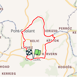
Circuit du pont Coblant - Gouézec

tracegps
User


3h00
Difficulty : Medium

FREE GPS app for hiking
 SityTrail
IGN / Geographical institutes
SityTrail Plus
The world is yours!
About
Trail Walking of 11.6 km to be discovered at Brittany, Finistère, Gouézec. This trail is proposed by tracegps.
Description
Circuit proposé par la Communauté de Communes de la région de Pleyben. Départ du parking de l’Eglise de Gouézec. Retrouvez le circuit sur le site de la communauté de communes de la région de Pleyben . Ce circuit a été numérisé par les randonneurs du CODEPEM. Merci à Jean-Marie.
Photos


Positioning
Comments