


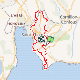
st chamas nature et patrimoine longue

mic-13
User

Length
18.2 km

Max alt
111 m

Uphill gradient
261 m
Km-Effort
22 km

Min alt
-1 m

Downhill gradient
262 m
Boucle
Yes
Creation date :
2019-04-23 15:55:21.193
Updated on :
2019-04-23 15:55:21.345
4h43
Difficulty : Medium

FREE GPS app for hiking
 SityTrail
IGN / Geographical institutes
SityTrail Plus
The world is yours!
About
Trail Walking of 18.2 km to be discovered at Provence-Alpes-Côte d'Azur, Bouches-du-Rhône, Saint-Chamas. This trail is proposed by mic-13.
Positioning
Country:
France
Region :
Provence-Alpes-Côte d'Azur
Department/Province :
Bouches-du-Rhône
Municipality :
Saint-Chamas
Location:
Unknown
Start:(Dec)
Start:(UTM)
665358 ; 4822866 (31T) N.
Comments