


dounoux mp

lacote
User
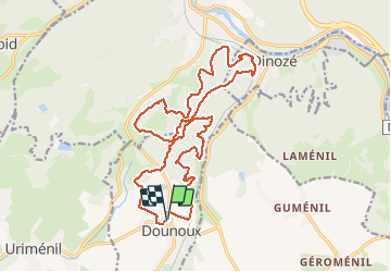

Length
21 km

Max alt
512 m

Uphill gradient
555 m
Km-Effort
28 km

Min alt
362 m

Downhill gradient
556 m
Boucle
Yes
Creation date :
2019-01-15 16:19:58.057
Updated on :
2019-01-15 16:19:58.057
3h43
Difficulty : Medium

FREE GPS app for hiking
 SityTrail
IGN / Geographical institutes
SityTrail Plus
The world is yours!
About
Trail Walking of 21 km to be discovered at Grand Est, Vosges, Dounoux. This trail is proposed by lacote.


Positioning
Country:
France
Region :
Grand Est
Department/Province :
Vosges
Municipality :
Dounoux
Location:
Unknown
Start:(Dec)
Start:(UTM)
309679 ; 5331375 (32U) N.
Comments