Trail Walking Kerpert - circuit des fontaines  Kerpert  - Photo

circuit des fontaines Kerpert

© OpenStreetMap contributors
Length
Length
10.2 km
Max alt
Max alt
298 m
Uphill gradient
Uphill gradient
226 m
Km-Effort
Km-Effort  
13.2 km
Min alt
Min alt
211 m
Downhill gradient
Downhill gradient
227 m
Boucle
Boucle
Yes
Creation date :
2019-01-15 16:21:02.674
Updated on :
2019-01-15 16:21:02.674

(0 Reviews)

Walking
Walking
2h39
Difficulty : Medium

Scan this QR Code to open this trail in the SityTrail application

FREE GPS app for hiking

Logo SityTrail SityTrail

IGN / Geographical institutes

Download SityTrail from the App Store Download SityTrail from Google Play

Logo SityTrail SityTrail World

The world is yours!

Download SityTrail from the App Store Download SityTrail from Google Play Download SityTrail on Huawei AppGallery

About

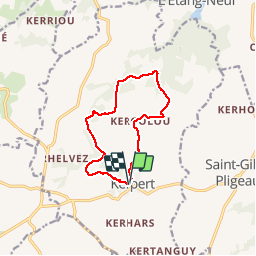
Trail Walking of 10.2 km to be discovered at Brittany, Côtes-d'Armor, Kerpert. This trail is proposed by ollivier.albert.

Description

beaucoup de sous-bois

Elevation profile

Photos

Positioning

Country:
France
Region :
Brittany
Department/Province :
Côtes-d'Armor
Municipality :
Kerpert
Location:
Unknown
Start:(UTM)
490022 ; 5358228 (30U) N.

Trails nearby

Trail Walking Kerpert - circuit des moulins, Kerpert - Photo
Walking
ollivier.albert

Walking

Medium
Kerpert, Brittany, Côtes-d'Armor, France
5.7 km | 7.4 km-effort
1h 36min
Yes
Trail On foot Kerpert - Circuit de la vallée - Photo
On foot
PRO

On foot

Easy
Kerpert, Brittany, Côtes-d'Armor, France
4.9 km | 6.6 km-effort
1h 30min
No
Trail On foot Kerpert - Circuit des Fontaines - Photo
On foot
PRO

On foot

Easy
Kerpert, Brittany, Côtes-d'Armor, France
9.7 km | 12.8 km-effort
2h 53min
Yes
Trail On foot Kerpert - Circuit des Moulins - Photo
On foot
PRO

On foot

Easy
Kerpert, Brittany, Côtes-d'Armor, France
5.4 km | 7.2 km-effort
1h 37min
No


Close
My subscriptions