


recobota2018

raymondfn
User
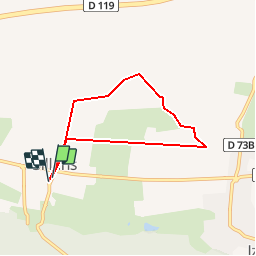

Length
6 km

Max alt
420 m

Uphill gradient
36 m
Km-Effort
6.5 km

Min alt
395 m

Downhill gradient
34 m
Boucle
Yes
Creation date :
2019-01-03 22:01:04.784
Updated on :
2019-02-24 11:24:01.163
41m
Difficulty : Very easy

FREE GPS app for hiking
 SityTrail
IGN / Geographical institutes
SityTrail Plus
The world is yours!
About
Trail Walking of 6 km to be discovered at Auvergne-Rhône-Alpes, Isère, Sillans. This trail is proposed by raymondfn.
Description
Azéri
Positioning
Country:
France
Region :
Auvergne-Rhône-Alpes
Department/Province :
Isère
Municipality :
Sillans
Location:
Unknown
Start:(Dec)
Start:(UTM)
687339 ; 5023676 (31T) N.
Comments