


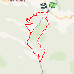
grimone serre les têtes l'aupillon

gloup26
User

Length
8.1 km

Max alt
1704 m

Uphill gradient
535 m
Km-Effort
15.3 km

Min alt
1319 m

Downhill gradient
531 m
Boucle
Yes
Creation date :
2019-01-15 16:29:36.268
Updated on :
2019-01-15 16:29:36.268
3h03
Difficulty : Unknown

FREE GPS app for hiking
 SityTrail
IGN / Geographical institutes
SityTrail Plus
The world is yours!
About
Trail Walking of 8.1 km to be discovered at Auvergne-Rhône-Alpes, Drôme, Lus-la-Croix-Haute. This trail is proposed by gloup26.
Positioning
Country:
France
Region :
Auvergne-Rhône-Alpes
Department/Province :
Drôme
Municipality :
Lus-la-Croix-Haute
Location:
Unknown
Start:(Dec)
Start:(UTM)
710310 ; 4952090 (31T) N.
Comments